
Conservation Blog
Our conservation blog is where we keep you up-to-date on what is happening related to conservation in Pickens County and beyond!
State of South Carolina Governors Proclamation:
We are excited to announce that Governor Henry McMaster has issued a Governor’s Proclamation proclaiming April 24 – May 1, 2022 as Soil and Water Stewardship Week!
Rain Gardens in Pickens County:
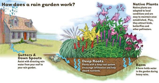
Recently, an impressive amount of rain has fallen in South Carolina. With excess rainfall, also comes an increased potential for stormwater runoff. A landscape feature that can help mediate stormwater is a rain garden. Rain gardens are landscaped depressions that receive stormwater runoff and allow the water to infiltrate the soil slowly, eventually reaching the groundwater table. A rain garden can add both beauty and functionality to any landscape. Multiple plant species can be used in a rain garden, including shrubs, perennials (both shade and sun-loving), and grasses. To learn more about rain gardens or about how to become a Master Rain Gardener:
Land Conservation: Jocassee Gorges
In the uppermost reaches of South Carolina, the clear waters of Lake Jocassee splash against the base of the Blue Ridge Escarpment, a "Blue Wall" of hills that represent the sharp transition between our Carolina Mountains and Piedmont. Here forested slopes drop in elevation by 2,000 vertical feet in a matter of one to two miles. This steep forested condition represents the Escarpment's general character throughout its length in Virginia, the Carolinas and Georgia. Around Lake Jocassee (from the South Carolina/Georgia line eastward to Jones Gap State Park), however, a series of steep-sided gorges carrying surging mountain rivers and streams down to the Piedmont has cut the generally uniform sloping face of the Escarpment. These gorges together are known as the Jocassee Gorges. Streams with names such as Saluda, Eastatoe, Laurel Fork, Toxaway, Horsepasture, Bearcamp, Thompson, Whitewater, Devils Fork and Chattooga carved these rugged gorges and produced scenic waterfalls and other natural beauties. These gorges, their streams, and the more than 75 inches of precipitation that occurs here each year make this area unique among mountain settings in the eastern United States. The name "Jocassee," according to Native American legend, means "Place of the Lost One." Evocative Indian names echo throughout the Jocassee region, such as Oconee and Eastatoe, both tribes which inhabited the area. T
he Eastatoees were called the Green Birds and likely received their name from the Carolina parakeet, the only parrot native to eastern North America, a species that became extinct in 1904. The Eastatoe valley was the last site where scientists recorded a sighting of the species in South Carolina. This region has drawn the attention of scientists for centuries. It is where, in the mid-1700s, William Bartram discovered the flame azalea along with other species new to science, and enjoyed "a view inexpressibly magnificent and comprehensive" from the crest of Oconee Mountain (now Station Mountain). In 1787, botanist Andre Michaux discovered his "small plant with saw-toothed leaves" that today is recognized as Oconee bells, a rare plant species that is a hallmark of the Jocassee Gorges. It was also the location of many detailed botanical studies that in the mid-1900s documented the unique qualities of the Jocassee Gorges region. During the past century, much of the land has been owned and managed by commercial timber interests. In more recent years, the area has also been the site of important wildlife and fisheries restoration projects involving white-tailed deer, wild turkey, peregrine falcons, and brook trout, among others. Perhaps most important, this mountainous region across the upper reaches of South Carolina and adjacent North Carolina and Georgia has been the site of major conservation and land preservation efforts over the past decades. These efforts involved federal and state agencies, land trusts, conservation groups and corporations.
These organizations have provided for us, and future generations, a protected landscape and ecosystem that will ensure the continuation of important natural resources while allowing compatible and safe use by the public. Jocassee Gorges was protected thanks to a cooperative acquisition effort between the S.C. Department of Natural Resources (DNR), Duke Energy and the Richard King Mellon Foundation, assisted by The Conservation Fund. Recently completed and proposed acquisitions of these Jocassee Gorges lands by state and federal agencies -- and the establishment by Duke Energy of a conservation easement on portions of its retained holdings -- ensure the continued protection of significant natural and recreational resources. It also provides an important physical linkage with extensive Mountain Bridge Wilderness Area lands to the east and National Forest lands to the west. Together, these areas, plus conservation lands in adjacent North Carolina and Georgia, provide protection for about 150,000 acres associated with South Carolina's Blue Ridge Escarpment and its watersheds. Jocassee Gorges tract contains about 43,500 acres. The S.C. Department of Natural Resources owns most of this land, and activities here are governed by a management plan and regulations they've developed, in large part, in response to public input. The U.S. Forest Service proposes to purchase land on the western edges of the tract and will manage these holdings as part of Sumter National Forest. Duke Energy, the former owner of all the Jocassee Gorges tract, has maintained ownership of some of the lands for the operation of its Bad Creek Pumped Storage Station. Duke Energy is also retaining other lands as an option for additional pumped storage hydro generation but has otherwise given up development rights through a conservation easement to the DNR. Public access to the Duke Energy lands is allowed.
Activities on the Duke-owned portions vary according to location, but the conservation easement ensures access and inclusion of the lands in the DNR's Wildlife Management Area program. The most important consideration in the Jocassee Gorges management plan is to maintain the natural character of the area. The secondary objective is to provide public recreation compatible with the area's natural character. Remember that the management plan is a living document and will evolve with time. Recreational activities provided for in the plan include hunting, fishing, hiking and horseback riding. The management plan also recognizes that Jocassee Gorges provides tremendous opportunity for scientific study and education. Many partners in addition to those already mentioned helped make the Jocassee Gorges acquisition possible. Among those partnering with the DNR were Duke Energy, Richard King Mellon Foundation; The Conservation Fund; North American Wetlands Conservation Council; S.C. General Assembly; S.C. Department of Parks, Recreation and Tourism; S.C. Forestry Commission; Clemson University; Governor's Office; South Carolina Congressional Delegation; U.S. Forest Service; The Nature Conservancy; National Wild Turkey Federation; the law firm of Nelson, Mullins, Riley and Scarborough; the Foothills Trail Conference; Trout Unlimited; S.C. Wildlife Federation; Sierra Club; and many other groups and private individuals.
For more information please visit: http://www.dnr.sc.gov/managed/wild/jocassee
Completion of Twelve Mile Watershed Upgrades Pickens Soil & Water Conservation District
We would like to first and foremost sincerely thank Pickens County Council for their help with funding the cost of the needed repairs and upgrades on the seven Twelve Mile Watershed flood control dams. In addition, Pickens Soil & Water Conservation District would also like to thank the following groups for their assistance and help on the completion of upgrades:
Pickens County Emergency Management
NRCS
SCDHEC
McCall Brothers Diving
The flooding disaster that hit our state in 2015 made us more aware of the need to keep all of the flood control dams in proper operating condition. All of the new hardware installed in the watershed structures was inspected by USDA-NRCS and SC DHEC personnel. Dam safety is the art and science of ensuring the integrity and viability of dams such that they do not present unacceptable risk to the public, property and the environment. The Pickens Soil and Water Conservation District is dedicated to the safety of the residents in Pickens County!
Soil Conditioning: Establishing a good foundation for your garden
The soil is often referred to as the “foundation of life”. The foundation must strong and healthy before great things can be developed. Most garden and landscape soils have poor soil texture and often lack organic matter, one of the most important additions any gardener can make. The soil is a medium comprised of mineral elements, soil particles, water, and living organisms, all of which are important to the overall health of the soil. The three primary soil particles are sand, silt, and clay. The relative percentages of these components present make up the soil’s texture. Texture is important to overall soil and plant health as it relates to soil porosity space, the pore spaces where air and water reside. The ideal soil texture is balanced mix of sand, silt, and clay particles, also known as a loamy soil. In most cases the particles will not be balanced and the soil will need to be altered by adding amendments.
To evaluate soil texture, use a simple jar test to determine the percentages of sand silt, and clay. For more information on the soil jar test, check out this video at the Clemson Extension Virtual Rain Garden
https://www.clemson.edu/extension/raingarden/virtual_rain_garden.html.
For all your Home & Garden needs please visit: https://hgic.clemson.edu/